
A GUIDE FOR THE INDEPENDENT TRAVELER IN THE AMERICAN SOUTHWEST
"With the completion of the Interstate Freeway System, it became possible to travel all the way across the country, from coast-to-coast, and never see a thing...." Charles Kuralt
It is a place where 3,000 feet straight down you can see the Colorado River rapids that were the last straw for three of Major John Wesley Powell's men (the first white men to ex plore down the Colorado in the Grand Canyon) back in 1869. Rather than face yet one more raging rapid they couldn't portage around, or any more of the hardships the last months had dealt them, they elected to climb out of the Grand Canyon, up a long lava slide, and try to make their way to civilization out the long Tuweep Valley.
You have to point out that when this all happened the Grand Canyon AND the Tuweep Valley were great blank spots on maps of the day. Major Powell and his men had floated the entire length of the Colorado from Green River City, Utah to what is now Lava Falls, a distance well over 300 miles. Their mission was to map the unknown, a mission that very soon became one of sheer survival. They lost boats and supplies in rapids whose awesome power turned strong men weak with fear, and when they reached Lava Falls they were exhausted, discouraged, low on supplies, and had no clear idea when they would come out of this great, deep, moody canyon and arrive at safety and civilization.
When the three men left the party, Powell gave them two rifles to hunt for food with, and wished them Godspeed. Powell continued on down river, and very soon the canyon walls widened out, the waters smoothed...the worst was over.
The men who climbed out were killed by Indians...
Just a little history to help underscore all the overwhelming impressions that sweep over you when you walk up and stand on the edge of Toroweap Point and gaze down, just a little startled by the suddenness of the impressive drop that appears before you, at the river 3,000 feet STRAIGHT down below your feet. The wind whipping up out of the canyon buffets your face and body and you involuntarily step back from the edge, you don't feel quite in control...and it is a lo-o-o-ng way to the bottom.
It is a long drive from the time you leave the paved highway about eight miles west of Fredonia. Sixty miles of dirt road. I'm not exaggerating...it is EXACTLY 60 miles (well, ok, 59.9 if you measure it exactly with a GPS receiver). But it is one heck of a place to go camping!
You drive out across a high, sun-swept, gently rolling desert. Be sure your tanks are full, be sure you have water and a spare tire; and if you're going to camp, take food. None of these things is at Toroweap Point, and most likely there will be nobody to help you if you get in trouble. There is a Park Ranger stationed there, but he might or might not be around. So be prepared to take care of yourself.
For the last ten miles or so you drive down the long Tuweep Valley. Just before entering Grand Canyon National Park there is an old wooden building up on the slope to your left. It was a church a rancher built for his wife long years ago. She couldn't readily get out to the nearest town, so she and her friends worshipped in this small structure. The first time I came into this valley, years ago, the wooden pews were still in the weathering structure. Somebody has taken them, and all that's left is the altar rail and the wooden floor. Wind and rain sweeps in through holes and cracks in the walls, and through glass-less windows.
The last few miles are slow going, and I suppose if you weren't alert, you could, conceivably, drive right off into the canyon. The road ends in a small pocket, protected from the wind; there are a couple of picnic tables and a porta-john off to one side. Park your car and walk a few feet...to the edge.
Toroweap, a Paiute term vaguely translated to mean a barren valley, refers to many local features, including the geologic formation and fault, the valley, and the overlook. Tuweep came into use to describe the local white settlement and later the park district. Tuweep in Paiute refers to "the earth," but this place name may be derived from a longer Paiute word meaning "long valley."
After miles and miles of desert and the long expanse of Tuweep Valley, it is a surprise...
It doesn't matter which way you look, the view will tighten the pit of your stomach and you will definitely NOT play "how close can I get?" games with the rock lip of the overhang. Be prepared for sudden assaults on the senses: a Swallow rocketing by with a perceptible WHOOSH of air sliding over its wings, playing jet fighter, dipping deep into the canyon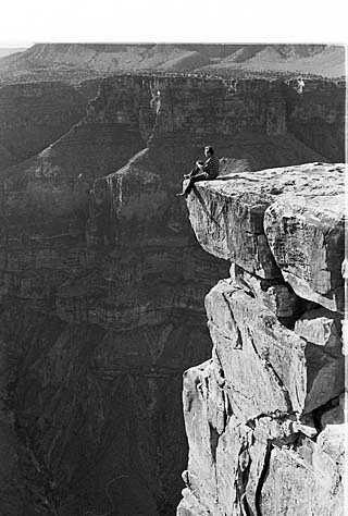 , pulling up in a screaming climb, wheeling back around to make another pass at you...The Toroweap Air Force.
If you are here to camp, the best part is you can pitch your tent right on the edge. I don't mean back up on the ridge in a nicely laid out camp ground, or a few feet back, I mean dangle-your-legs-off-the-ledge on the edge! Whatever you have the nerve to do.
I pitched my tent about 30 feet back, and even at that I was nervous...but what an experience.
It is a place to come when you are serious about getting away from it all, serious about taking care of yourself because there will likely be no one here to care for you. It is not a place for the casual weekender. The people who come here WANT to come here...and they seem to respect the place.
I hope you will, too.
INFO:
Maps are available at the Bureau of Land Management office in St. George, Utah, at nearby Pipe Springs National Monument, and at the U.S. Forest Service office i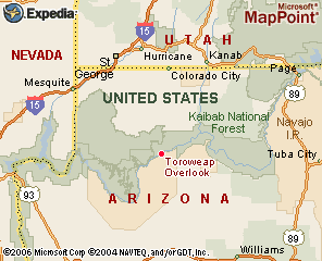 n Fredonia, Arizona.
To get to Toroweap Point, go 8.3 miles west on 389 from its junction with 89A in Fredonia, Az. Turn left of Mt Trumbull Road (big sign) (N36D 52.7465' W112D 38.8729'). There should be signs pointing you all the way. From the turnoff it is 59.9 GPS miles to the overlook.
At 40.3 (N36D 28.215' W113D 1.822') miles keep to left and you'll be on County Road 5. At 46.6 (N36D 23.335' W113D 3.556') miles bear left on what will be County Road 115.
At 54.1 miles, off to the left, you will see the Toroweap Ranger station.
At 57.4 (N36D 14.3750' W113D 4.4017' )miles stay straight or slightly left and at another 2.5 miles you will come to the unimproved camp sites at 59.9 miles. Go any further than this and you will take a very quick vertical flight down to the Colorado River, a distance of 2,831 feet, give or take a few inches.
Back at the 57.4 junction, if you go right, it will take you about 2.3 miles to the Lava Falls trail head. VERY rough, somewhat dangerous, and a 2,500 foot, STEEP drop to the Colorado River.
DO NOT attempt this if you are not in very good shape and take plenty of water and dress for rugged, hot conditions, especially in summer. Honestly, I can't be more serious about this, IT IS VERY DIFFICULT! I emphasize, you are in a VERY remote and lonely part of the world and help can be a LONG time arriving, if it arrives at all. You MUST take care of yourself!
ROAD CONDITIONS:
All routes are secondary county roads, graded occasionally and generally in good condition. The last three miles across the slickrock are the roughest. Allow 2-3 hours travel time from the highway to the overlook. RVs, trailers, or low-clearance vehicles are not recommended. All routes may be impassable after heavy rains and are subject to flash flooding. Tire damage from sharp rocks is common. Dangerous curves are often unmarked, and posted mileages may be inaccurate. Since there are few, if any, year-round residents, assistance is not guaranteed on any route.
For these reasons, no one should attempt the trip without ample preparation and knowledge of the hazards associated with remote desert travel. Travelers should carry extra WATER, FOOD, and GASOLINE; GOOD TIRES including at least one USABLE SPARE; and PARTS and TOOLS to handle vehicle and tire repairs.
FEES:
There are no charges for camping or day-use. A permit and fee are required for back country camping.
The campground is eleven primitive, first-come, first-served sites near the rim, including one group site. The group site may be reserved by calling (928) 638-7870. Sites may fill during spring months, especially on weekends. Picnic tables, fire grates, and composting toilets are provided, but no electricity or water is available. Bring your own firewood.
There are no services! Period. No gas, food, water, lodging, garbage collection A National Park Service ranger is stationed here year-round, but may not always be available. An emergency phone is located at the Tuweep Ranger Station.